What is GeoMesa?
GeoMesa is an open-source, distributed spatio-temporal database that provides a seamless solution for storing, querying, and analyzing large volumes of geospatial data. By utilizing GeoMesa, you gain the ability to efficiently store and query geospatial data across multiple distributed systems, enabling you to process vast amounts of data swiftly and accurately. Notably, GeoMesa boasts exceptional reliability and security, offering a robust feature set that caters to a wide range of applications, from surveillance operations to disaster relief efforts. Moreover, GeoMesa offers comprehensive support for cutting-edge geospatial technologies, including web mapping and GIS, allowing for effortless integration of your data into existing workflows. Regardless of whether you are a GIS analyst, data scientist, or application developer, GeoMesa equips you with the necessary tools to harness the power of geospatial data and unlock its full potential.
Information
- Price
- Contact for Pricing
Freework.ai Spotlight
Display Your Achievement: Get Our Custom-Made Badge to Highlight Your Success on Your Website and Attract More Visitors to Your Solution.
Website traffic
- Monthly visits2.44K
- Avg visit duration00:05:15
- Bounce rate43.49%
- Unique users--
- Total pages views8.01K
Access Top 5 countries
Traffic source
GeoMesa FQA
- Where can I download GeoMesa?

- How can I get started with GeoMesa?
- Where can I find the user manual for GeoMesa 4.0.4?
- Are there any previous releases of GeoMesa available?
- Is there any professional support available for GeoMesa?
GeoMesa Use Cases
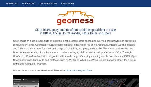
Store, index, query, and transform spatio-temporal data at scale in HBase, Accumulo, Cassandra, Redis, Kafka and Spark
GeoMesa is an open source suite of tools that enables large-scale geospatial querying and analytics on distributed computing systems
GeoMesa provides spatio-temporal indexing on top of the Accumulo, HBase, Google Bigtable and Cassandra databases for massive storage of point, line, and polygon data
GeoMesa also provides near real-time stream processing of spatio-temporal data by layering spatial semantics on top of Apache Kafka
Through GeoServer, GeoMesa facilitates integration with a wide range of existing mapping clients over standard OGC (Open Geospatial Consortium) APIs and protocols such as WFS and WMS
GeoMesa supports Apache Spark for custom distributed geospatial analytics
GeoMesa 4.0.2 is now available! See the release notes for more information
James Hughes and Emilio Lahr-Vivaz presented three talks at FOSS4G NA 2021, see the website for slides and videos
James Hughes presented 'Streaming IoT sensor data with LocationTech GeoMesa, Apache Kafka, and NiFi' at ApacheCon 2021, see the website for slides and videos
The GeoMesa project welcomes contributions from anyone interested
Join the user and developer email lists, and join the discussion on Gitter
For bug reports, additional support, and other issues, send an email to the GeoMesa listserv
Professional support is offered by GA-CCRi
The GeoMesa Project is supported by Locationtech, Eclipse, and GA-CCRi